Professional Surveying in Orlando, FL
As a leader in Orlando land surveying and mapping, our team uses state-of-the-art equipment and methods to deliver superior solutions for our clients. The tool kits accessible include Terrestrial Mobile and Static LiDAR, GPS systems, UAVs, Robotic and Reflectorless Total Stations, electronic field books, and proprietary data collection format. In addition, we also employ graphic production using MicroStation, ESRI ArcGIS, AutoCAD Land Development, AutoDesk Civil 3D, Revit, CAiCE, and GEOPAK tools to deliver compatible data in ready-to-use formats.
Land surveying is an essential for determining property boundaries and preparing maps of various land plots. No matter the size or scope of your project, our team of professionals are dedicated to your project from beginning to end. With over five decades of experience, institutional knowledge, and countless hours of research, we have solidified our long-term success in this industry. In addition to Orlando, we also service multiple other locations through our Jacksonville land surveying and mapping, Chipley land surveying and mapping, and Dothan land surveying and mapping services.
Specialties
- Boundary Surveys
- ALTA/NSPS Surveys
- Right‐of‐Way Location
- Section Corner Recovery
- Control Surveys
- Right‐of‐Way Mapping
- Topographic Surveys
- Maintenance Mapping
- Monumentation Mapping
- Sketch & Legal Descriptions
- Deed Research
- Title Search Review
- Subdivision Platting
- Platting Reviews
- Design Route Surveys
- Bridge Surveys
- Utility Infrastructure Surveys
- Tree Location Surveys
- Easement Surveys
- FDEP Submerged Land Lease Documents
- Elevation Certificates
- Mean High Water Surveys
- Aerial Photo Control/Targeting Surveys
- Cemetery Mapping
- Environmental Surveys
- Wetland Location Surveys
- Expert Witness Testimony
Full-Service Land Mapping & Surveys
We perform land mapping and surveys for both commercial and residential real estate projects. Our Orlando surveyors pride themselves on a distinctive collaborative approach which allows us to maintain open communication and flexibility during the development process. We deliver the most precise and cost-effective land surveying solutions in Orange County and the surrounding areas. We are also certified in Chipley subsurface utility engineering (SUE), Jacksonville subsurface utility engineering (SUE) services, and Orlando subsurface utility engineering (SUE) services.
As a leader in the industry, our surveying firm applies every level of traditional and non-traditional surveying and mapping technology available to achieve the best results possible for our clients. Qualifications by the Federal Highway Administration, Florida Department of Transportation, and Federal Department of Environmental Protection demonstrates that SSMC’s team, equipment, and methods to execute three-dimensional surveying and mapping are of the of highest standards. Call our office or submit a form request to schedule a consultation with one of our project managers at your convenience.
![]()
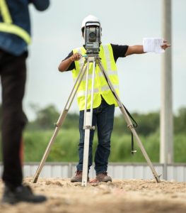
Location & Mapping
We apply a complete toolkit including GPS systems, electronic field books, and proprietary data collection format to create a precise location and map of any land plot.
![]()
Elevation Certificates
Elevation certificates document the lowest elevation point and flooding zone, among other features, to ensure the building site meets local ordinances’ requirements.
![]()
Topographic Surveys
The purpose of topographic surveys is to determine the horizontal and vertical spatial relation of selected features. Typically, they are used to design infrastructure improvements.
![]()
Boundary Survey
Boundary surveys are used to identify and document the perimeters of a parcel of land by establishing or reestablishing corners, monuments, and boundary lines.
![]()
Tree Location Surveys
Tree location surveys provide essential information on the trees located on your land including species, age, health, and measurements, as well as other features.
![]()
Control Surveys
Control surveys outline the foundational reference points for a project. By identifying these control points, we ensure consistency in all subsequent surveys.
Testimonials
“I had the pleasure of working with a couple of your employees over the past couple weeks. James Murphy and Beau Boyles; very professional and “can do” attitudes. They worked well with the crew from PSI and the task was completed one day ahead of schedule with no underground utilities damaged.”
Byron Osborn
NBC Universal, Orlando
“On behalf of our entire Project-87 team I want Southeastern Surveying to know that Mike Vetter and Ed Wolfrey set the Live Structural Steel Surveying performance bar to a new pinnacle with their Project-87 performance.”
Sean A. Murray Sr.
The Walt Disney Company
“Southeastern Surveying has been nothing but a pleasure to work with. Ian O’Gorman has truly been a great and trustworthy professional getting the jobs done in a clean and effective manner. Thank you for all of your hard work and efforts.”
TJ Kelley
Quanta Telecom Services
“We would like to take a moment to express our appreciation to the employees that worked with the City of Paxton Utilities Department. During the time we had the privilege of working with them; they were very professional and went above and beyond our expectations.”
Hayward Thomas
Mayor of the Town of Paxton
“Your guys out there were great, very professional and hard working.”
Scott Shelton
Rayken, Inc.
“Thanks again for a great job. Please let your team know how grateful we are to your tireless diligence in preparing a living database of information.”
Lisa Henry
City of Orlando